In order to collect data and answer scientific questions, scientists design and run experiments and conduct extensive fieldwork. These require planning, preparation, patience and a healthy dose of creativity. So what if you are trying to monitor the amount of land lost in a salt marsh over the course of a year? Does it require going out and physically measuring the marsh edge on a regular basis or could you capture the changes digitally? For the latter, you would need something reliable, tough and waterproof to stand up to the changing tides and the harsh weather conditions of a coastal salt marsh. CWC scientists Giovanna McClenachan and R. Eugene Turner, both of Louisiana State University’s Department of Oceanography and Coastal Science, tackled this challenge with every surfer, paddler and adventurer’s best friend – the GoPro®!
Scientists have been studying coastal marsh erosion (or land loss) in Louisiana and along the Gulf Coast for years because salt marshes are vital to local fisheries and tourism. Erosion of the marsh edges can occur naturally due to tidal and wave action but there is also evidence that human related activities and disturbances are causing the rate of erosion to increase in some locations. McClenachan and Turner are specifically interested in how exposure to oil (like from the 2010 spill) effects the rate of erosion. They chose a study site in Bay Batiste in Plaquemines Parish, Louisiana to try out their GoPro camera setup and were able to capture photos at two-hour intervals during four to six-week periods from August 2014 to September 2015!
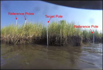
McClenachan and Turner attached two GoPro cameras to a PVC pole that was initially 1.5m from the marsh edge and aimed at a target pole. Additional poles were placed to the left and right of the study site to serve as reference markers in the pictures. The cameras, designed to function in any number of conditions, took photos throughout each day capturing the changing tides, passing storms and the gradual decrease in soil around the marsh grass roots. Using these images, the scientists saw that more sediment was lost during times when the roots of the marsh grass were dead. This happens naturally each year but can also occur when the marsh is exposed to oil and other pollutants. The marsh grass dies or their root systems are damaged and they can no longer serve as a stabilizer for the sediment. Moreover, since studies are showing that remnants of oil can remain in the sediment for years, scientists are worried about the long term impacts of the spill on the stability of marshland.
We don’t have all of McClenachan and Turner’s data, as they haven’t published this study yet, but it seems safe to make some general conclusions: 1) land loss is happening, 2) healthy grass and root systems help stabilize marsh sediment, 3) exposure to oil appears to increase the rate of land loss in marshes, and 4) there is a lot more research that needs to be done.
**McClenachan and Turner put together a time-lapse video to show the dramatic changes to this segment of marsh during the study period. Watch carefully and you will notice the additional poles added to mark the new marsh edge as sediment erodes away.**

One thought on “Using GoPro cameras to monitor land loss”