The following is a summary of “Islands in the oil: Quantifying salt marsh shoreline erosion after the Deepwater Horizon oiling” written by R. Eugene Turner, Giovanna McClenachan and Andrew W. Tweel, published in the Marine Pollution Bulletin in September 2016 (Volume 110, Issue 1, 15 September 2016, Pages 316–323)
The 2010 Deepwater Horizon disaster was the worst oil spill event in U.S. history. Approximately 4.9 million barrels of Macondo oil were released into the Gulf of Mexico just 66km from the Louisiana coast. As clean up and restoration efforts began, it became clear that there was a severe lack of baseline data for the ecosystems and wildlife in the region. There has been a concerted effort over the past six years to monitor and record the short and long-term impacts of the spill in order to understand the extent to which oil affects an environment. Conveniently (from the scientific viewpoint), the marshes and islands of Louisiana were inconsistently oiled and provided a “potential natural laboratory” of control and experimental sites. Scientists could observe oiled and unoiled marshes that experienced the same natural tides, weather conditions, and human impacts over the same period of time. This type of experimental conditions are rare outside of a controlled laboratory situation.
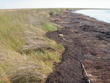
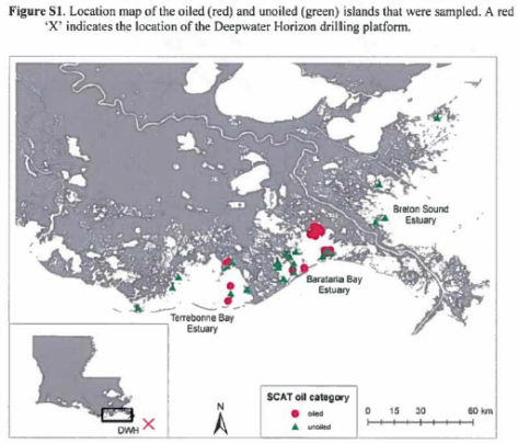
Drs. Eugene Turner, Giovanna McClenachan and Andrew Tweel used this opportunity to monitor shoreline erosion – a key issue for Louisiana salt marshes. They had three primary questions: 1) How much faster did oiled shorelines retreat?, 2) How long do the effects of oiling last?, and 3) Is there recovery?. Using Google Earth satellite and aerial imagery and classifications from a multi-agency damage assessment organization (SCAT – Shoreline Cleanup Assessment Technique), 46 islands in Barataria and Terrebonne Bays were selected as study sites. Islands classified as heavily, moderately or lightly oiled were used as ‘oiled sites’ while those given the no oil designation were used as ‘unoiled sites’. Imagery stored publically on Google Earth provided images of the selected sites from 1989 to 2012 and enabled the scientists to measure the length and width of each island over time. Using these images, they were able to determine the erosion rate for the 20 years prior to the oil spill and establish a baseline to compare with the erosion rate following the spill.
After analyzing the data, the scientists determined that the rate of erosion at oiled islands for the first 12 months following the spill was 275% of the pre-spill erosion rate. That translates to an erosion rate nearly three times as fast as that seen before the spill and at unoiled sites. However, there was no detectable difference between the rates at oiled and unoiled sites after a year and a half. This suggests that there was some degree of recovery or stabilization over those 18 months. These results are consistent with those from other studies that tracked erosion rates after a shoreline was exposed to oil. Turner, McClenachan and Tweel stated that the resiliency and strength of the marsh sediment comes from the belowground biomass – the root system. Without the stability from the roots, sediment is easily washed away by the tides and regular wave action. This study demonstrated that the increased erosion rate caused by exposure to oil does slow over time but did not provide any evidence of recovery in affected marshes. Additionally, these scientists do not believe there can be a reversal to the damage without management intervention.
This is one of many studies examining Louisiana’s coastline and waterways. They are focused on a number of different issues pertaining to erosion, vegetation, food webs, soil, and microbial communities, but there are a few consistent messages emerging: a loss of habitat stability ripples through to all aspects of the community. Salt marshes and estuaries are vital nursery grounds for marine life that form the bedrock of Louisiana’s economy. The islands serve as resting spots and nesting grounds from local and migratory birds. In fact, 11 of the 30 Brown Pelican nesting sites along the Gulf are in Barataria and Terrebonne Bays. Without the islands and marshes, mainland Louisiana is at a higher risk for hurricane damage and sea level rise. They are essential habitats for the social and economic future of the state.
To read the full article:
http://www.sciencedirect.com/science/article/pii/S0025326X16304507
